 |
| St Mary's Mapleton |
Mapleton from the footpath leading to the Tissington Trail. In the background is Thorpe Cloud and Bunster Hill. Curiously, Mapleton is sometimes spelled Mappleton. I wonder which is correct?
Button waiting patiently for her gate to be opened at the stile. The path leads through to the embankment carrying the Tissington Trail. The weather today was a little disappointing. Sunshine had been promised but it was mostly cloudy.
The Tissington Trail is a disused railway line that has been converted to a footpath and cycle track. The line used to run from Ashbourne to Buxton but was closed in 1963 and the trail was established in 1971.
A log from a felled tree has been converted into a welcome, trail side seat.
Button can't really understand why I might want to stop and take a rest and look at the view.
Not much of the railway architecture remains but this substantial bridge, built from engineering bricks, carries a farm track over the trail.
The verges to the trail are well vegetated and have many wild flowers. This picture shows "Queen Anne's Lace" or cow parsley. I also saw red campion, herb bennett, ramsons, speedwell, buttercups, ox-eye daisies, forget-me-nots and others.
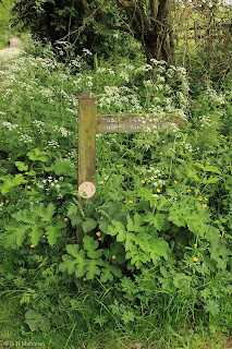
The path leaves the trail at this point. The signpost is short and nearly hidden in the foliage!
St Leonard's, Thorpe. The tower is the oldest part of the church and dates from the 11th century. The round arched windows are typical of Saxon and early Norman architecture. The South Porch bears marks on each side of the outer doorway said to have been caused by the repeated sharpening of arrows. in the 14th century every Englishman was required to have a bow and arrows kept ready for use. Sunday afternoons were to be devoted to archery practice "on the South side of the Church".
The simple and peaceful interior of St Leonard's.
Leaving Thorpe village near to Coldwell bridge is this milestone. At one time this must have been a significant road but now it is no more than a farm track. Coldwell bridge itself is a substantial structure and crosses the River Dove.
The River Dove from Coldwell bridge. We are below Dovedale at this point and the Dove flows more tranquil through woods and meadows.
An unusual gate at Dove Cottage. The footpath here is very clearly marked and access has been assured by the farmer at Dove Cottage. The gate is well constructed and works very well.
A clear path has been left through this cereal crop. Button, however, loves charging through the corn and bounding up to see where she is!
The end of the walk, approaching Mapleton (or is it Mappleton) with the Italianesque church and the village pub.
All photos will enlarge somewhat with a click.
(All photos, Canon EOS 60D, Sigma 17-70mm)


I'm glad you decided to post your whole walk, it makes interesting reading and I have enjoyed it!
ReplyDeleteI find it can be very time consuming to write posts detailing a whole walk - and to select which photos to include - but I think it's worth the effort!
Great stuff! Is there a market for this type of article in the world of magazines? A second career?
ReplyDeleteI'm glad you both like this. I will try and repeat the effort from time to time but it is quite time consuming so I won't be doing every walk like this!!
ReplyDelete